|
Click here to transmit an email to the authors with corrections or
updates. Please include your name and telephone number for the
authors so they may communicate with you if there are questions. If
you wish to speak with the authors by telephone, call 520-432-5783.
. . . Thank you . . .
Grassland Information
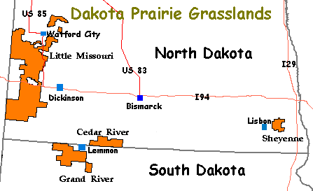
Cedar River National Grassland (NG), one of four grasslands in the Dakota Prairie Grasslands, is 6,717 acres in a cluster of public holdings sprinkled along the southern end of North Dakota and northern end of South Dakota - see map below. The grassland is administered by the Dakota Prairie Grasslands office and the nearest town to the grassland is Lemmon, SD. There are no developed campgrounds. The authors visited Cedar River during July 2009.
The areas now designated as "grasslands" were settled in the 1800s under a variety of "Homestead Acts" which opened the land to people, generally farmers, and helped to settle the west. A prolonged period of drought in the late 1920s into the 1930s caused some homesteads on sub-marginal farmland (a location receiving 15 or less inches of annual moisture) to literally dry up and blow away. During this time, Congress established the Land Utilization Program (LUP) which bought homesteads from bankrupt private owners and returned it to public land status. The Civilian Conservation Corps (CCC) helped to stabilize the eroding soil by re-seeding it and applying other conservation techniques. In the 1950s, the LUP holdings were assigned to the USDA Forest Service which was tasked with management of these sub-marginal lands. Over the years the Forest Service has established some twenty National Grasslands. "The designation of the area as National Grassland is not a description of the area as much as a statement of policy and effort to restore the area to a multiple of uses and benefits."
It is easy to miss Cedar River NG. It isn't big - only a collection of disconnected parcels used by the area's ranchers for grazing their cattle. There are no developed recreational opportunities, not even a designated trail. However, the scenic beauty of the area provides opportunities for sightseeing and photography. Birdwatching is also a popular activity in this grassland. There are opportunities for tent campers to discover some nice dispersed camping locations such as the one at GPS coordinates: N46 03.12, W101 19.780 - elevation 2,000 ft.
Between 1891 and 1892, 720, 800-pound seven foot quartzite markers were placed every half mile from Minnesota to Montana to designate the boundary between North and South Dakota. Each marker has information carved on three sides. Chiseled on the north face is "N.D." and on the south face is "S.D.". On the east face is an "M" and above that letter is a number representing the mileage from the marker and the initial marked at the Minnesota border. A number of these markers can be found in the southern sections of Cedar River NG.
In some ways, exploring Cedar River National Grassland is more interesting than the other grasslands since it is so less developed. Like searching out the quartzite boundary markers or finding a perfect dispersed campsite, Cedar River NG is more an adventure into an uncharted land.
ADDRESSES
SUPERVISOR ADDRESS
2000 Miriam Circle
Bismarck, North Dakota 58501
701-989-7300

RANGER DISTRICT ADDRESS
Grand River
1005 5th Ave West
Lemmon, South Dakota 57638
605-374-3592 |