Campground List
CAMPGROUND NAME: Boykin Springs
VISIT DATE: 02/21/1997
UPDATE DATE: 10/7/2017
STATE: Texas
REGION: Southern
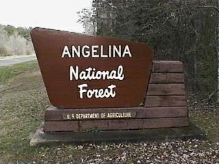
RANGER DISTRICT: Angelina
NEAREST CITY/TOWN: Zavalla
RESERVATIONS: No
DIRECTIONS:
In Zavalla, TX, at the intersection of State Rts.147 and 63, take
Rt. 63 east 10.6 miles to Boykin Springs Recreation Area sign
(Forest Rt. 313). Turn right onto Rt. 313 and go 2.6 miles to
campground. Once inside campground, turn left before Picnic Area
for camping area. Combined sites are to the right at the "T"
intersection and tent-only sites are to the left.
GENERAL COMMENTS:
The elevation is 200 feet.
The original campground and Boykin Springs Lake were built in 1937 by
the Civilian Conservation Corps (CCC). Hurricanes Rita and Ike destroyed
or damaged much of the campground and it had not fully recovered by the
time of the authors' visit. There are two areas for camping. The more
RV-friendly section, Loop B, is to the right of the "T" intersection.
The second area (no name) for tents, is accessed using a low-water bridge
and is near the Spillway's Day Use area. The lack of signs makes the
campground difficult to navigate and low branches and unkempt appearance
add to the confusion. The campground's only bathroom is located between
the two areas, below the spillway. Although the bathroom is wheelchair
friendly, access is not. The swim area is located near the campground's
entrance and is a long walk from the campsites. The sites are tucked in
among Loblolly pine and mixed hardwoods providing ample shade and good
privacy.
The campground has character and there is much to explore. A hike to the
ruins of Aldridge Sawmill on the Sawmill Trail (or driving most of the way
on Forest Rt. 326), is an interesting day trip. The Aldridge Sawmill,
closed in 1910, provides insight into the area's industrial past.
SEASONS
Open Seasonal: No
Open All Year: Yes
RATE AND MAXIMUM STAY PERMITTED
Rate: $6 per day
Maximum Stay Permitted (days): 14
CAMPGROUND SITE CONFIGURATION
No. RV Sites: 0
No. Tent Sites: 9
No. Combined Sites (Tent or RV): 8
Total Sites: 17
Tent Pads: Yes
Open Sites: No
Wooded Sites: Yes
No. Tables on Sites: 17
No. Grilles on Sites: 17
Equestrian Camping: No
RV INFORMATION
Hookups: None
No. RV Pull Throughs: 0
Waste Station: No
Average Parking Apron Size: 11' X 35'
Comments:
The parking aprons are broken asphalt or dirt. Be aware of low overhanging
branches both in campground and access to it.
BATH AND SHOWER FACILITIES
Vaults: No
Flush Toilets: Yes
Hot Showers: Yes
Comments:
Flush toilets and hot showers located in day-use area only.
OTHER FACILITIES
Playground: No
Public Phone: No
No. Water Spigots (non-site): 8
No. Threaded: 8
Wheelchair Friendly Toilets: Yes
WATER SPORTS
Lake: Yes
Swimming (provided): Yes
Sailing: No
Boat Ramp: No
Boat Carry Down Access: Yeso
Power Boating: No
Boating (no power): Yes
Water Skiing: No
Rafting (whitewater): No
Kayaking (whitewater): No
Comments:
Boykin Springs Lake is 9 acres.
HIKING
Lakeshore Trail
Sawmill Trail
Old Aldridge - 2.5 miles
FISHING
Catfish, Bream and Largemouth bass.

CAMPGROUND NAME: Caney Creek
VISIT DATE: 02/21/1997
UPDATE DATE: 10/7/2017
STATE: Texas
REGION: Southern
RANGER DISTRICT: Angelina
NEAREST CITY/TOWN: Zavalla
RESERVATIONS: No
DIRECTIONS:
In Zavalla, TX, at the intersection of State Rts. 147 and 63, take
State Rt. 63 east 4.2 miles to Caney Creek Recreation Area sign
(Farm Rd. 2743). Turn left onto Rt. 2743 and go 5.2 miles to
campground sign. Turn left at sign and go 1.4 miles into campground.
GENERAL COMMENTS:
The elevation is 100 ft.
The campground, located on the Sam Rayburn Reservoir in mature hardwoods
and pine, has two loops - Elm and Pine. Many of the campsites have a
view of water. There is a pleasant breeze through the campground off the
lake in the afternoon. The campground's primary feature is a huge boat
ramp. The rest of the campground is sadly under-maintained with parking
aprons covered by a thick layer of leaf litter and damaged tables and
grills.
SEASONS
Open Seasonal: No
Open All Year: Yes
RATE AND MAXIMUM STAY PERMITTED
Rate: $6 per day, per vehicle
Maximum Stay Permitted (days): 14
CAMPGROUND SITE CONFIGURATION
No. RV Sites: 0
No. Tent Sites: 1
No. Combined Sites (Tent or RV): 26
Total Sites: 27
Tent Pads: Yes
Open Sites: No
Wooded Sites: Yes
No. Tables on Sites: 26
No. Grilles on Sites: 19
Equestrian Camping: No
RV INFORMATION
Hookups: None
No. RV Pull Throughs: 0
Waste Station: Yes
Potable Water at Waste Station: No
Average Parking Apron Size: 10' X 48'
Comments:
The parking aprons are eroded with broken asphalt and dirt and poorly defined.
The interior road is rough and be aware of low overhanging branches in the
campground and along the access road.
BATH AND SHOWER FACILITIES
Vaults: Yes
Flush Toilets: No
Hot Showers: No
OTHER FACILITIES
Playground: No
Public Phone: No
No. Water Spigots (non-site): 0
Wheelchair Friendly Toilets: Yes
Comments:
The vaults are located on each side of boat ramp making it a long walk from some
campsites. Only the vault on the Pine Loop side of boat ramp is wheelchair
friendly.
WATER SPORTS
Lake: Yes
Swimming (provided): No
Sailing: Yes
Boat Ramp: Yes
Boat Carry Down Access: Yes
Power Boating: Yes
Boating (no power): Yes
Water Skiing: Yes
Rafting (whitewater): No
Kayaking (whitewater): No
Comments:
Sam Rayburn Reservoir is 114,500 acres.
HIKING - No
FISHING
Largemouth bass, White perch, catfish, drum and bream
|